MAPPING PROJECT
Mapping Project
About the Project
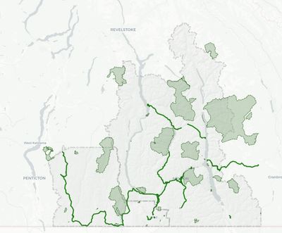
The West Kootenay Cycling Coalition (WKCC) has developed an online interactive map of existing and proposed cycling routes of the West Kootenay’s. This map is an ongoing effort to provide an updated inventory of cycling opportunities and assist with data collection for planning purposes. Users are encouraged to provide feedback both for improving the map itself and for planning future active transportation projects in our region. (*Be advised that the map prioritizes transportation routes over recreational trails . ** Be advised that this map is not definitive in scope. It is constantly evolving.) The WKCC does not assume responsibility for any errors.
The target audiences and purposes are:
- To provide the public with opportunities;
- To provide feedback comments to the WKCC on suggestions and priorities for improvements to the cycling network;
- To provide feedback to the WKCC on locations where safety issues are apparent;
- With the view to do route planning for commuter and recreational distance cycling purposes.
- To provide Agencies/authorities (e.g. Municipalities, Regional Districts and Ministry of Transportation and Transit with recommendations for;
- remediation or upgrading
- expanding route linkages
- align with transit options
Users will be able to select from a range of attributes and overlays e.g.
- Trail surface e.g. gravel or asphalt
- BC transit stop locations
- Dedicated lane, shared road, multi-use path. Etc.
Users will be able to:
- View existing cycling routes and opportunities
- Provide feedback comments about trail/route priorities, conditions and problems to the WKCC by email.
- To view updated information regularly on WKCC priorities for improvements to the cycling network as suggested by the public.
Taghum Footbridge
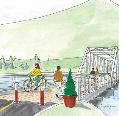
Taghum Footbridge Project
The West Kootenay Cycling Coalition endorses this project. In fact, a pedestrian bridge connecting Blewett to Taghum is in our Active Transportation Plan.
The Taghum Footbridge Society is working to promote walking, biking and outdoor activities that connect our local communities while creating an outdoor meeting place, wildlife viewing platform, and stargazing destination across the Kootenay River. By reusing and updating the existing historic 1930s pier infrastructure, we achieve up to 50% savings off a new build while boosting tourism, supporting local businesses like Taghum Shell and Taghum Hall, and generating over $20 million in economic benefits for our region over the next decade. For more information visit: https://taghumbridge.org/
Castlegar/Nelson Active Transportation Corridor PROJECT

Castlegar - Nelson Active Transportation Corridor Vision Project
The study is complete and we have a plan that we'll be presenting it to the RDCK board on September 12th.
The study assessed the feasibility of developing a year-round, multi-use path to connect Castlegar and Nelson. The corridor would ideally be a 45 km long active transportation route that encompasses all forms of mobility, including walking/rolling, cycling, transit, commuting to work, getting to school, recreation, socializing or running errands with the benefit of supporting active lifestyles and reducing greenhouse gas emissions. Our end goal for this study was to create a plan with a viable route, including recommendations for any additional amenities or infrastructure needed to realize our vision. Various options and preferences have been determined through stakeholder meetings, physical surveys, a review of traffic statistics, project research and comparison studies to other similar projects already successfully completed. The West Kootenay Cycling Coalition and WATT Consulting Group, in consultation with RDCK, have mapped out a potential path and the draft plan was prepared for presentation to the public for engagement. We hosted a series of 6 open houses and conducted a digital survey to help us obtain feedback. From the data collected, a final plan was completed and presented by staff planners to the RDCK board of directors on August 15th, 2024.
On September 12, 2024, the West Kootenay Cycling Coalition (WKCC) will be formally presenting this plan to the RDCK board directors. The WKCC will be requesting that the plan be adopted in its entirety. WKCC will also present some capital funding options starting with a motion to approve the immediate application for grant funding to implement the first segment from the City of Nelson to Taghum. This segment is approximately 8 km long and includes a pedestrian bridge to be built on the existing pilings from a former highway bridge. This bridge will be a key piece of infrastructure directly linking Blewett residents and Taghum Beach Regional Park to Taghum Community Hall and all the neighbourhoods on the north side of the river. The WKCC has already presented this plan to various groups living and working within this area and have received widespread support. This will be a vital link offering a safe, convenient route for pedestrians and cyclists. Once built, the WKCC anticipates significant use helping to reduce vehicle traffic, parking issues and emissions in the area. This segment will provide the WKCC with a solid foundational experience with which to move forward with the completion of the remaining segments as outlined in the plan.
You may review the plan in PDF format below:
OTHER Infrastructure Improvement Projects

Trail Active Transportation Network Plan
The WKCC is supporting the City of Trail in the creation of an Active Transportation Network plan after the city of Trail was awarded a $50k grant from the government of BC
South Kootenay Green Link
The WKCC is supporting the RDKB in the creation of an Active Transportation Network plan between the cities of Fruitvale and Rossland known as the South Kootenay Green Link after the RDKB was awarded a $50k grant from the government of BC.
Nelson North Shore shoulder improvements
The WKCC is working with the RDCK, MOTI, and YRB to make improvements to the Nelson North shore section of Highway 3A
Canada wide cargo e-bike rental program
The WKCC, in partnership with Bike Winnipeg, Bike Regina, Halifax Cycling Coalition, and the Kelowna area cycling coalition is working on forming a Canada wide cargo e-bike rental co-op program.
Silverton-New Denver Active Transportation Route
The WKCC is in the early planning stages of a Silverton-New Denver Active Transportation route